Can you use a Q-route below FL180?

Max Trescott - 2008 National CFI of the Year
David asked the following:
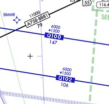
“Hi, I have a question about Q-routes. I understand they were developed for class A airspace. However, the Q100 airway out of Tampa, Florida has a 6000 foot MEA and a 1500 foot MOCA. Can you use this airway assuming you have /G and say fly at 7000 feet on an IFR flight plan?”
Great question David. So great that it took some research and phone calls to the FAA! As background for readers, Q-routes and T-routes are relatively new types of airways defined by GPS waypoints and requiring an IFR-capable receiver. They were created to handle the increasing density of air traffic and to take advantage of the widespread availability of GPS. T-routes are low altitude airways and Q-routes are high altitude airways. Per the AIM, Q-routes can be flown as low as FL180.
Q100 appears on a low altitude en route chart, which normally is used only for navigating below 18,000. So that begs the question: Why does a
Q-route
Q-route, which can only be used above FL180, appear on a low altitude chart which is only used for navigating below FL180? I didn’t know, so I called the experts, the FAA’s RNAV/RNP group. They thought it was a very good question too. Which is why they had to make 3 phone calls to find out–and they’re the experts!
The answer back was No, you probably cannot get a clearance to fly this route even if you filed for it, unless you were flying above FL180. The reason it appears on the chart–at least for now–is that it was one of the first GPS airways, and it was created before the altitude rules were established (in 2003 as I recall) for T- and Q-routes. Thus it’s a legacy, which doesn’t really belong on the chart. But now that you’ve asked us and we’ve asked the FAA, don’t be surprised if it disappears from future charts. So save your current chart. It may become a collectors’ item!
Jeffrey on May 21, 2009
That was a good question.
That sounds like a question a sneaky DE could throw out there during an IFR check ride to see how “much” you really know!
What is a q-route? | Ask a CFI on May 22, 2009
[…] is great follow-up question to a previous post, “Can you use a q-route below FL180?”. The question came to me after posting a link to that post on my Twitter […]
Eric on May 23, 2009
Max, I was under the impression that T-routes required an IFR enroute GPS receiver, and that G MEAs (which can appear on a T-route with an existing, normal MEA) required WAAS. John over at Aviation Mentor seems to be of the same mind.
Do you have any FAA documentation on the requirements? I’d love to be able to point at it when I’m covering instrument cross country planning with my students.
William Lahners on Jul 23, 2010
I fly a BE58 from KSRQ to KHDC (Tampa area to New Orleans area) and have been given the Q100 at 10000, FYI.
Kevin Tomczak on May 17, 2012
As with William (above), we have gotten clearance to fly a “Q” route below 180. I think it depends on how ATC wants to sequence you and your traffic. I have also gotten a Victor airway clearance above 180, so go figure. I argued with ATC that we couldn’t accept the clearance since we were flying at FL310. So, we flew the airway until our clearance was ammended by another center down the road.
Ross on Sep 28, 2012
Thanks I was looking at the low IFR charts down here in Orlando and noticed the Q routes so was condering why it was on there, I can now explain this to my stuents!
P on Dec 17, 2012
You could find a G also on a Victor Airway. Lowest MEA with the use of GPS. it could be lower than the VOR – VOR Victor Airway MEA.
Remember the requirement to check the Predictive RAIM when flying Q or T routes.
retiredZDV on Feb 15, 2013
As strange as those Q routes with the 6000′ MEA are, we’ve got something weirder out here in ZDV. Almost all of our Q routes have MEAs, but they’re in the low to mid flight levels. For example, Q152 between IKFOM and ONL VORTAC has an MEA of 24,000. Q122 between LCU VORTAC and KURSE has an MEA of 28,000.
Our terrain, high as it is, doesn’t get anywhere near those altitudes, and it doesn’t seem navaid reception should be a problem with GPS…
ZSE guy on Jun 02, 2014
The reason some Q routes have (or had) MEAs on them is that you used to be able to fly Q-routes with RNAV-equipped a/c that use an RNAV system based on ground NAVAIDs, like the older-school DME/DME receivers.
Those systems are usually augmented by GPS or an IRU, but they still use NAVAIDs, which means reception becomes an issue in mountainous terrain, and thus you see MEAs that are intended to guarantee that reception.
James Venetti on Nov 07, 2014
Max most likely called and FAA guy who does not deal ACT routing like I do.
Q-Routes begin at and above 18,000 ft and if you file a Q route and you intend climb or descend at or through 18,000 feet the controller will issue the Q route routing which clearance is issued by ATC exactly the same as Jet routes are. The routing regulation is also stated in the ATP 7110 Air Traffic Procedures Manual for Center and Tower Controllers.
The answer is yes… if you file for a T, Q, J or V route above or below the route’s altitude and the controller issues a clearance via that route then it is approved and you may now fly outside the intended cruise altitude of that route. The same rule applies to Jet routes… if you are on a J8 route and cleared down to 10,000 feet you may not leave the Jet route even though you are below the designated altitude. You must stay on the route and it is done everyday and all the time. If you request the route outside the limit and ATC issues a clearance then Fly -on my friend.
Neil Fogle on Mar 07, 2015
I fly Q100 and Q 102 with an IFR certified GPS VFR between 8,500 and 10,500 with flight following regularly. If you notice there is only one compulsory reporting point depicted on either airway at CIGAR. Center will advise you that you will be out of radar and radio contact beyond a certain point and will usually give you a frequency and tell you to contact Houston or Jacksonville at a point here they know you will have coverage. After jotting down the frequency and contact point I monitor the frequency until I here center tell some one up in class A to contact the next sector on such and such a frequency. I change frequencies knowing that I can contact one of the big boys upstairs if need be.
Now having said all that I routinely hear Houston Center working helicopters in the gulf operating at low altitudes. I believe that is made possible by the fact that the copters are ADS-B equipped. It would be my assumption that Q 100 and Q 102 will become T routes when ADS-B is mandatory.
Thanks for the information.
Dean R. Brock on Sep 24, 2016
I too have been on the Q-routes over the Gulf many times and had IFR traffic operating below FL180, as well as having routinely operated above FL180 on a Victor Airway clearance and below FL180 on a Jet Route clearance. The controller and the veteran pro pilot, above (James and Neil) have a lot of credibility.
Blaine Nay on Jan 16, 2017
It’d sure be nice to have a lot more T-routes, especially in the Rockies.